 |
|
|
||||
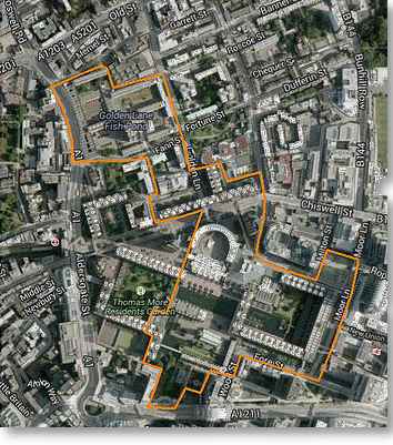
The City of London spreads across a square mile of land and is divided into 25 geographic areas, or 'Wards'. Four of these Wards (Aldersgate, Portsoken, Queenhithe and Cripplegate), are described as 'Residential' as they contain the vast majority of all City residents. The Ward of Cripplegate provides part of the Northern edge of the City and stretches from just below Old Street, down to London Wall at its Southern tip, where it meets the Ward of Bassishaw. To the West is the Ward of Aldersgate and on the Eastern edge is Coleman Street. The 2003 Ward Boundary Review recommended some significant changes for a number of Wards and these were eventually implemented in 2013; the orange line on the aerial picture (right) shows the latest boundary for Cripplegate. The Cripplegate Ward boundary used to extend a great deal further South, all the way down to Cheapside in fact. The Ward was home to the Livery Halls of 6 Worshipful Companies and now only one remains (The Barber-Surgeons in Monkwell Square). Further information on the history of Cripplegate Ward can be found in the Book "The Ward of Cripplegate in the City of London", click here for ordering information . Each Ward is represented by an assembly called the 'Court of Common Council'. This consists of 100 Common Councilmen and 25 Alderman (one for each Ward). The number of Councilmen allocated to each particular Ward is based on the size of the electorate and where Cripplegate used to warrant 12 members of Council it is now reduced to 9. Further information on Cripplegate's Councilmen can be found by clicking here. The City of London Corporation provides a useful map that shows the current boundary of all 25 Wards and you can zoom-in to show quite high degrees of detail. |
|
|
||
 |